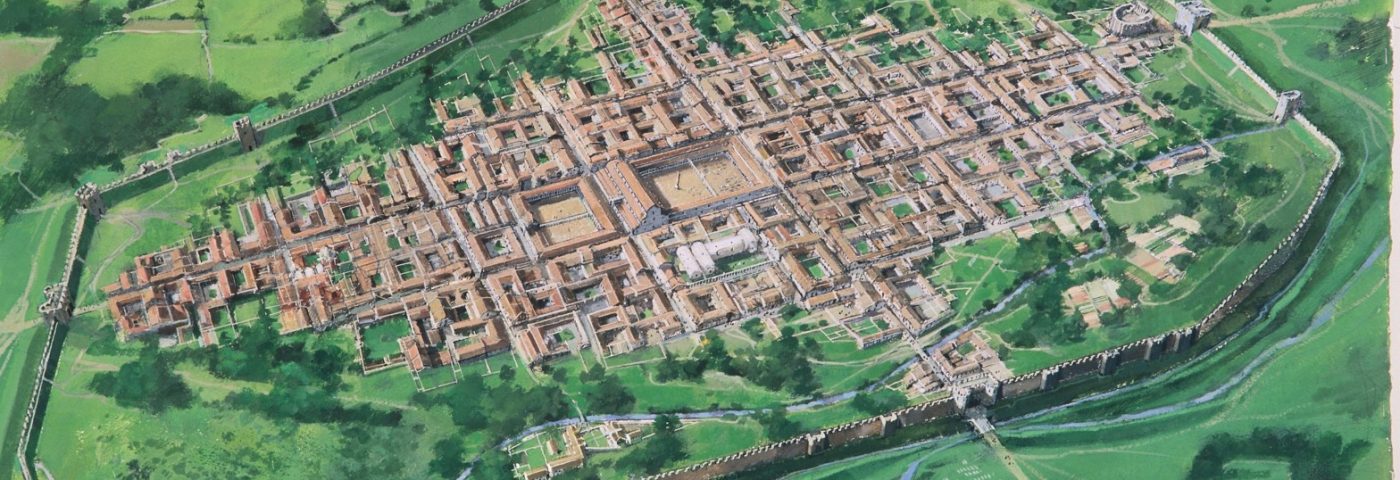
It is obvious that the decision to establish the Romano-British town of Corinium Dobunnorum roughly 1900 years ago, has directly influenced the location of the present town of Cirencester. Puzzlingly, if transported back to the same spot at the time of the Roman invasion, one would be surprised to find a boggy, marshy landscape prone to seasonal flooding; not exactly an obvious spot for dense urban occupation. With knowledge gained through centuries of expansion, the Roman engineers must have realised the obvious challenges they would encounter in such a setting. The area chosen was essentially an island in the middle of two rivers; the Daglingworth Brook and the Churn. When Corinium was built, extensive drainage works had to be carried out to divert the rivers away from the town, a task of great effort and expense. When Roman occupation of Britain ended abruptly in the early fifth Century AD, these defences were no longer maintained, resulting in the medieval occupation of the town being reduced to the dryer northern area.
Corinium Dobunnorum as it may have looked in the fourth century AD
Fort-Vicus-Town?
The peculiar choice of location is traditionally explained as growing out of a previous civilian settlement known as a vicus, which was associated with a Roman auxiliary fort. It is evident that a fort was discovered in Cirencester which dates to the early Roman occupation. However, there is little archaeological evidence for any long-lived civilian activity, and the fort itself is marked out primarily by a pair of very unsubstantial ditches, due to the high-water table. The recovered finds do little to prove any long-lived occupation, and instead point to two brief periods of fort activity, perhaps no more than six months each. If this is the case, then a fort and any associated vicus were very short-lived. In fact, when the public building works first took place around the end of the first century AD, the basilica was built on top of the backfilled fort ditches, leading the walls to crack due to their unstable foundations. This perhaps indicates that by the time the town was constructed the previous military related activity had been largely forgotten. Therefore, the story of the town’s formation is a little more complex.
Who was the town created for?
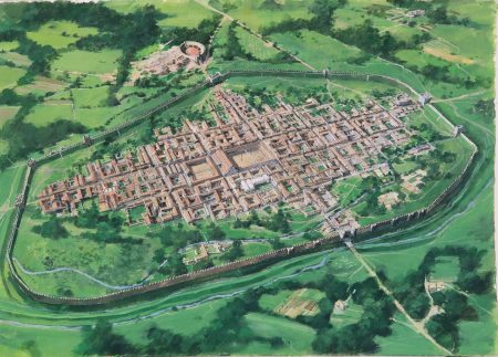
Corinium was created as a civitas capital, locally administered, and not typically a place populated by actual people from Rome. But who were these people, and how much say did they have in the formation of the new town? Elsie Clifford’s pioneering archaeological excavations in the 1950’s at Bagendon, 5 km north of Cirencester, have provided plenty of evidence of a pre-existing hierarchical social structure; centred around a site referred to as an ‘oppidum’. Oppida are a feature of the Late Iron Age (c.100 to c.43 AD) in Britain and are thought to have played a dominant role in the formation of towns. They are notoriously hard to define, but at a basic level the word is Latin for ‘town’. In Britain, archaeologists use the term to label a distinct type of large British complexes which are sited on low-ground with discontinuous earthworks, therefore marking them out as a new phenomenon to the preceding hillforts. Generally, it is thought that oppida were the centres of influential individuals whose power rested on access to luxury goods from the Roman world. It is easy to imagine the effect that ownership of items such as wine, exotic jewellery and supplies of silver and gold would have had on the status and prestige of these individuals; gaining them a wide scale of political authority, disrupting the previous social organisation that existed in Britain before this time.
The Bagendon oppidum (RCHME 1976)
The oppidum at Bagendon is largely abandoned around the same time as Corinium is established. There are no archaeologically visible signs of conflict at Bagendon, and there is also no visible resistance against the Romans throughout the whole region. This strongly points to the same individuals being involved in the creation of the town, but if so, why did they decide to choose a new spot and not simply stay put at Bagendon?
Why Cirencester?
The most obvious explanation is that the town was built where it was convenient for the Roman road system, as Corinium is located at a junction where all the major roads meet. However, it has been demonstrated that this is not exactly the case.
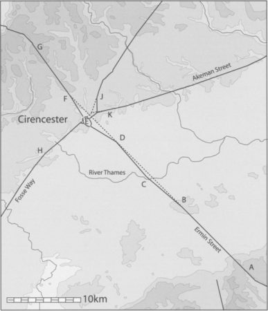
Illustration of the main Roman roads at Cirencester. The dotted lines demonstrate how the roads veer off their straight alignments on the approach to Corinium (Reece 2003).
The image above demonstrates that Corinium is not placed in the most appropriate location for the main Roman roads. Instead, each major road must divert off its natural alignment in order to arrive at each of the town’s four gates. The decision not to place the urban settlement at the more logistically appropriate location, may be due to the existence of two (possibly three) Late Iron Age, or reused Bronze Age round barrows, known as Tar Barrows. The construction of Corinium where it was most convenient would have resulted in the destruction of a locally significant site, one that continued as a religious complex throughout the Roman period. Such activity may well have revolved around the worship or remuneration of the deceased family of the native elites by the local population. Similar ‘elite’ cemeteries have previously been discovered at the Colchester and St Albans oppida. With the significance of Tar Barrows in mind, the peculiar layout of the road system at Cirencester is more explainable.
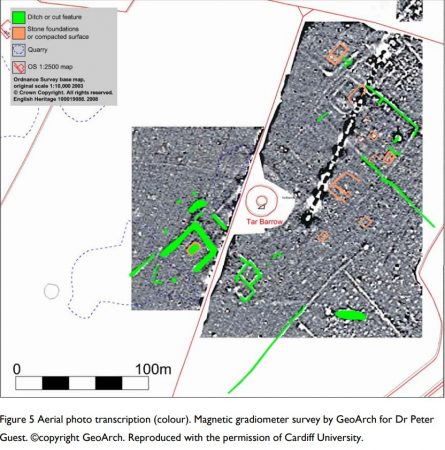
Geophysics results of Tar Barrows indicating that the Late Iron Age/ Early Roman site was important throughout the Roman period (Winton 2009; Cardiff University).
Towns and floodplains
Many urban settlements of Roman Britain are built on floodplains including Winchester, Canterbury, Lincoln, London, Exeter and Leicester. At Canterbury, a branch of the River Great Stour flowed through the Romano-British town. This floodplain zone attracted activity from at least the Late Iron Age. There are traces of a possible Iron Age shrine here where a later temple complex and forum‐basilica were constructed. This waterscape may have been instilled with meaning which could have informed the siting of the town, regardless of its ‘convenience’ for settlement. Was this also the case at Cirencester?
The Roman Empire was polytheistic in outlook, and the Romans were generally accommodating of existing beliefs, as long as the Roman gods were acknowledged or equated with local gods. This is further evident in the ‘double-barrel’ dedications of temples across Roman Britain. In the Cotswolds, the most famous examples are the temples to Mars/Nodens at Lydney and Sulis/Minerva at Bath. It is therefore possible that the formation of Roman towns in Britain involved a similar process of negotiation. If the Roman conquest of Britain involved adapting the pre-existing political landscape into the Roman system, then there is no reason why towns could not have formed in relation to certain local beliefs and systems, as long as they were still established (on paper at least) as a Roman town. Ultimately, it can be reasoned that Corinium’s foundation was the consequence of a nearly 2000-year-old compromise between two parties; to site the town to both local, and Roman requirements.
Written by Nicholas Jones
This blog is based on research carried out in coordination with Corinium Museum, for the unpublished MA Dissertation: Jones, N. 2018. Domination or negotiation? An archaeological interpretation of the events which led to the foundation of Corinium Dobunnorum. Cardiff University.
Sources
Clifford, E., 1961. Bagendon: A Belgic Oppidum. Cambridge: Heffer and Sons.
Collis, J. 1984. Oppida: Earliest Towns North of the Alps. Department of Prehistory and Archaeology, University of Sheffield.
Creighton, J. 2000. Coins and Power in Late Iron Age Britain, Cambridge: Cambridge University Press.
Diaz-Guardamino, M, Snjuan, G. L., and Wheatley, D. (eds). 2015. The Lives of Prehistoric Monuments in Iron Age, Roman and Medieval Europe. Oxford: Oxford University Press.
Frere, S. 1977. ‘Roman Britain in 1976: Sites Explored’, Britannia 8, pp. 356–425.
Giles, M., 2012, A Forged Glamour: Landscape, Identity and Material culture in the Iron Age. Oxford: Windgatherer Press.
Haselgrove, C. and Moore, T. 2007. ‘New narratives of the Later Iron Age’, in Haselgrove, C. and Moore, T. 2007. The Later Iron Age in Britain and Beyond. Oxford: Oxbow Books, pp. 1-15.
RCHME (Royal Commission on the Historical Monuments of England), 1976, Ancient and Historical Monuments in the County of Gloucestershire Volume 1: Iron Age and Romano-British Monuments in the Gloucestershire Cotswolds. London: HMSO.
Reece, R. 2003. ‘The siting of Roman Corinium’. Britannia Vol. 34, pp. 276-280.
Rogers, A. 2012. ‘Water and the Urban Fabric: a study of towns and waterscapes in the Roman period in Britain’. International Journal of Nautical Archaeology, Vol 41 (2). Southsea: The Nautical Archaeological Society, pp.327-339.
Rogers, A. 2013. Water and Roman Urbanism: Towns, Waterscapes, Land Transformation and Experience in Roman Britain. Mnemosyne Supplements: History and Archaeology of Classical Antiquity 355. Leiden and Boston: Brill.
Winton, H. 2009. Tar Barrow, Cirencester, Gloucestershire: A Roman or Iron Age ceremonial area: aerial photo interpretation and mapping: archaeological report. Research Department Report Series no.51-2009. Swindon: English Heritage.


Comments
Really interesting as a resident to get these theories based on other findings around the origins of the town.
Will pass on to another interested party.
That’s a fascinating account and has opened my eyes to possibilities that had not occurred to me. I had wondered about the unusual road alignments, and I wonder if the Fosse Way was originally on a more northerly alignment. The boundary ditch and bank with its military road must predate the building of Corinium. There may still be evidence underground along the original alignment. Perhaps there was a causeway through the flood plain north of the town, like the one north-west of Cricklade on Ermin Street.
The analysis of the Roman Road layout does not take account of the straight alignment of the Fosse from Stow-in-the Wold for many miles south-west until it was cranked to the right to converge on Corinium. The same happened to its extension as it approached the town from the south-west. This road also cranked – somewhere near Kemble. These changes of direction were not done to avoid a natural obstacle or difficult terrain. It was to diverge away from the original crossing point with Ermin Street which was much nearer to the oppidum of the Dobbuni at Bagendon and in south Stratton – why place a fort nearly 4 miles away from the tribal assembly place in a flood plain? Please respond with archaeological evidence of the foundation date of the first fort.